 The best road atlas for truck drivers is by far the Rand McNally Motor Carriers’ Road Atlas.
Talk to just about any truck driver that uses a road atlas (a lot of them still do) and they will tell you the atlas is a must have accessory.
Since I have started driving a truck (in 2011) I have used this Rand McNally atlas almost on a daily basis while I was driving OTR.
Once I started driving regionally I started to rely on it a little less because it’s not uncommon to drive the same route several times a month.
Wait, what about my GPS?
I’m not saying I don’t use a GPS, I do. I have just found that relying completely on a GPS isn’t the way to go all the time. A backup is needed and the Rand atlas is the perfect one.
I’m not one of those old school truckers that still solely uses a paper atlas for navigation. I’m not.
I use my GPS, Rand Motor Carriers’ Atlas, Google Maps, and a lot of common sense for route planning and have been doing just fine out here.
A few questions for you to ponder if you think I’m crazy?
1. What are you going to do when your GPS freezes? What happens when it stops working for some odd reason?
2. What is your backup in case your GPS is wrong? It is going to be wrong sometimes, I guarantee it. What are you going to do?
3. Why wouldn’t you want to have a backup (paper atlas) to help navigate?
What Are You Going To Do When Your GPS Freezes?
Trust me, eventually your overpriced GPS is going to freeze on you and won’t be accessible. What are you going to do if you are in the middle of a route and need directions?
I have the answer!
Open up your atlas and use your brain to actually plan a route yourself. This is how truckers used to do it before GPS and they did just fine.
Rand McNally has been making the most user friendly and accurate atlas that I have ever seen and the best thing about it is they don’t cost a lot of money. It will never freeze on you, need charging, need a software or maps update, and are easy to use.
What Is Your Backup In Case Your GPS Is Wrong?
You might think the GPS is always right, but it’s not. I remember a lot of times where using my atlas was more accurate than my GPS. Personally, I also like knowing that in case my GPS is wrong I always have a back up.
Just open it up and flip to the state you are looking for and start planning. So simple.
Why Wouldn’t You Want A Backup (paper atlas) To Help Navigate?
Sometimes I come across other drivers (usually really young ones) that laugh at me when they see that I still use a paper atlas.
They just haven’t had enough time to figure out how useful having a paper atlas is or no one bothered to tell them. I guarantee that after a few more months they too will have a paper atlas like mine.
Alright, now that I have convinced you that you need to get this (link to it on Amazon) Rand Atlas for truckers I want to explain why. Below are some more reasons you should get one and a few tips I discovered after I bought one that will help you out.
Get The Laminated And Spiral Bound One
I learned this the hard way. Being the cheapskate that I am I bought the “regular” non laminated/spiral bound version. After a few months the pages had stains on them and started to tear from being used over and over.
Sure, the laminated version (this one) does cost a little more but it’s well worth the money. It took me about 3 months to finally fork over some more money for the laminated version but I am so glad I did. Oh well, now I have 2 of them!
The laminated and spiral bound version is going to last much longer since I don’t have to worry about tears and spilling stuff on it.
Another bonus of having laminated pages is that you can color on them. Read more about that next.
Use A Dry Erase Marker On It
This is a great tip that I heard from another driver. He told me to get some dry erase markers (like these) and use them to highlight my route on the laminated pages.
Use a red (or any other color) dry erase marker to highlight your trip and then erase it when you are finished.
I use an old sock to erase the marker. Remember, since this is a dry erase marker you don’t need to use a wet sock. The sock has to be dry.
Check out the video at the end of this article to see what I mean.
Don’t Rely On The Atlas Alone
As much as I like my road atlas I don’t rely on it alone for route planning.
I do still use a GPS and a lot of common sense. Also, I use Google maps to help navigate. Google Maps is great. You do have to have an internet connection to use Google Maps though. The one major downside of Google Maps is that there isn’t a version or setting for truck drivers. It assumes you are driving a car, not a tractor trailer.
Another trick is to call the receiver to find out where is the best place to enter the dock. Is it around back? Is it in front? Is it a difficult backup? Using all of these tools will ensure you aren’t wasting time and getting to your destination as quickly and safely as possible.
Make Sure You Get the Motor Carriers’ Atlas
An easy mistake to make is to buy the “regular” road atlas. If you are a truck driver you need to get the Rand McNally Motor Carriers’ Atlas, the link to it on Amazon is right here.
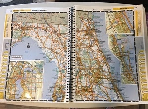
This one has been specifically made to help you find safe truck routes. It will show bridge and overpass heights, weight restrictions, and which roads to avoid because they are not for trucks. The roads that are good for trucks are highlighted in yellow so they are easy to follow.
Shows Weigh Station Locations
I know, I didn’t expect this either. Since this was my first paper atlas I didn’t’ expect it to show weigh station locations. It does! Very nice!
There Is A Larger Print Version For Older Drivers
I just found this out recently but there is a larger print version also available for older drivers or drivers that can’t see very well.
A link to the larger print one on Amazon is right here.
From what I was able to gather the print on these are 37% larger than the regular atlas. Other than the larger print I’m pretty sure it’s the same thing.
Don’t Expect A Lot Of Detail
Keep in mind that this atlas is made for truckers. You aren’t going to find a ton of detail on it. It isn’t going to show vacation areas and a ton of points of interest (it does show some).
The purpose of this atlas is to help truckers navigate. If you want an atlas with more detail you should get the regular road atlas that Rand makes, not the trucker version.
No Auto Updates
Unlike a GPS you will need to get a new one every few years. Roads do change but I honestly don’t think you need to get a new one every year.
I have the 2018 version (I’m writing this in 2018) and will probably use it for several years. In a couple of years I’ll get the newest version and then use it for another few years.
Like I said earlier, you should be using the atlas with your GPS, Google Maps, and some common sense. Google Maps and your GPS are constantly being updated. Your common sense….who knows.
It’s Big
Don’t expect a pocket size map. It’s about 11 inches wide and 16 inches height when closed. It weight is probably near 4 lbs.
It will take up a little space but it’s well worth it. Make some room for it.
Get It Cheaper By Waiting
A tip that I have heard is that buying the atlas as soon as it comes out is a mistake. You are better off waiting a few months when the price goes down. I’m not sure how true this is but more than a few drivers told me about it.
How To Use The Rand McNally Atlas Video
Not being someone who is willing to get in front of a camera I have instead searched YouTube for the best video showing how to use the Rand McNally Atlas.
You can get a good idea how the atlas looks and some great tips on how to use it. The video is from a few years back but the map hasn’t changed much. I like how he demonstrates how to route plan with the dry erase marker. Check out the video below:
You might think that paper maps and atlases are not being used by truckers anymore. That is just not true. I think you’d be surprised to know that a lot of truck drivers still use a paper atlas for navigation.
They may no longer be the primary source for planning a route but they are the best backup in case the electronics stop working.
I never leave home without mine.